Portal:Mountains
| |
|
|
Introduction


A mountain is an elevated portion of the Earth's crust, generally with steep sides that show significant exposed bedrock. Although definitions vary, a mountain may differ from a plateau in having a limited summit area, and is usually higher than a hill, typically rising at least 300 metres (980 ft) above the surrounding land. A few mountains are isolated summits, but most occur in mountain ranges.
Mountains are formed through tectonic forces, erosion, or volcanism, which act on time scales of up to tens of millions of years. Once mountain building ceases, mountains are slowly leveled through the action of weathering, through slumping and other forms of mass wasting, as well as through erosion by rivers and glaciers.
High elevations on mountains produce colder climates than at sea level at similar latitude. These colder climates strongly affect the ecosystems of mountains: different elevations have different plants and animals. Because of the less hospitable terrain and climate, mountains tend to be used less for agriculture and more for resource extraction, such as mining and logging, along with recreation, such as mountain climbing and skiing.
The highest mountain on Earth is Mount Everest in the Himalayas of Asia, whose summit is 8,850 m (29,035 ft) above mean sea level. The highest known mountain on any planet in the Solar System is Olympus Mons on Mars at 21,171 m (69,459 ft). (Full article...)
Selected mountain-related landform

U-shaped valleys, also called trough valleys or glacial troughs, are formed by the process of glaciation. They are characteristic of mountain glaciation in particular. They have a characteristic U shape in cross-section, with steep, straight sides and a flat or rounded bottom (by contrast, valleys carved by rivers tend to be V-shaped in cross-section). Glaciated valleys are formed when a glacier travels across and down a slope, carving the valley by the action of scouring. When the ice recedes or thaws, the valley remains, often littered with small boulders that were transported within the ice, called glacial till or glacial erratic.
Examples of U-shaped valleys are found in mountainous regions throughout the world including the Andes, Alps, Caucasus Mountains, Himalaya, Rocky Mountains, New Zealand and the Scandinavian Mountains. They are found also in other major European mountains including the Carpathian Mountains, the Pyrenees, the Rila and Pirin mountains in Bulgaria, and the Scottish Highlands. A classic glacial trough is in Glacier National Park in Montana, USA in which the St. Mary River runs. Another well-known U-shaped valley is the Nant Ffrancon valley in Snowdonia, Wales. (Full article...)
Selected mountain range
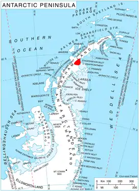
Pippin Peaks () is an east-west line of several Antarctic peaks ranging in height from 880 m to 1,160 m and formed of white or pink granite. The feature is situated in the southern Aristotle Mountains, at the west end of Stubb Glacier where it forms a part of the glacier's north wall, and is connected to Mount Sara Teodora to the west-southwest.
The name is one of several in this area applied by United Kingdom Antarctic Place-Names Committee (UK-APC) from Herman Melville's Moby Dick, Pippin being the shipkeeper in the Pequod who was cast adrift by Stubb. (Full article...)
Selected mountain type
Geomorphology is a peer-reviewed scientific journal about geomorphology. (Full article...)
Selected climbing article
Mountaineering: The Freedom of the Hills is often considered the standard textbook for mountaineering and climbing in North America. The book was first published in 1960 by The Mountaineers of Seattle, Washington. The book was written by a team of over 40 experts in the field.
The book grew out of the annual climbing course run since 1935 by the Mountaineers, for which the reading material was originally a combination of European works and lecturers' mimeo outlines. These were assembled into the Climber's Notebook and published by the Mountaineers as the hardbound Mountaineers Handbook in 1948. By 1955 the rapid postwar evolution of climbing techniques and tools had made the Handbook out of date, and the effort was begun to produce Freedom of the Hills. Nearly 80 major contributors are credited in the first edition and were organized by a committee of 8 editors. (Full article...)
Related portals
General images


 Alpine flora near Cascade Pass (from Montane ecosystems)
 Car of Horská služba (Czech Republic) (from Mountain rescue)
 Fixed lines and ladders are distinguishing characteristics of expedition style mountaineering. (from Mountaineering)
 Antique climbing tools (from Mountaineering)
 The city of La Paz reaches up to 4,000 metres (13,000 ft) in elevation. (from Mountain)
 A stand of mountain birch at around 750 m in Trollheimen, typical of Scandinavian subalpine forests (from Montane ecosystems)


 Choppering out the injured – with Mt. Forbes in the background (from Mountain rescue)
 The Andes, the world's longest mountain range on the surface of the Earth, have a dramatic impact on the climate of South America (from Mountain range)
 Mountaineers proceed across snow fields on South Tyrol; other climbers are visible further up the slopes. (from Mountaineering)
 This 1848 "Sketch showing the actual elevation of the Snow Line in different Latitudes" by Alexander Keith Johnston shows the snow lines of mountains in America, Europe and Asia (from Snow line)
 Edelweiss, a plant associated with mountain sports (from Mountaineering)
 A mountain rescue team in Iran moving a casualty. (from Mountain rescue)
 Stretcher box in Cumbria, England, prepositioned equipment saves mountain rescue teams having to trudge up mountains with it. (from Mountain rescue)
 Fuji volcano (from Mountain)
- Mountaineers climbing in South Tyrol (from Mountain)
.jpg.webp) Mountaineers, circa 1900 (from Mountaineering)
Mountaineers, circa 1900 (from Mountaineering) The northern Urals at high latitude and elevation have an alpine climate and barren ground. (from Mountain)
 A climber taking the final few steps onto the 6,160 m (20,210 ft) summit of Imja Tse (Island Peak) in Nepal, 2004 (from Mountaineering)
 Granite Park Chalet in Glacier National Park, US (from Mountaineering)
 Mountain hikers on the mountain (from Mountaineering)
 The Ocean Ridge, the world's longest mountain range (chain) (from Mountain range)

- Mount Everest, Earth's highest mountain (from Mountain)
 The Himalayas, the highest mountain range on Earth, seen from space (from Mountain range)


 Mountain rescue team members and other services attend to a casualty in Freiburg Germany. (from Mountain rescue)
.jpg.webp) Iranian oak scrub in the Zagros Mountains (from Montane ecosystems)
Iranian oak scrub in the Zagros Mountains (from Montane ecosystems)
Selected skiing article

Nordic combined is a winter sport in which athletes compete in cross-country skiing and ski jumping. The Nordic combined at the Winter Olympics has been held since the first ever Winter Olympics in 1924, while the FIS Nordic Combined World Cup has been held since 1983. Many Nordic combined competitions use the Gundersen method, where placement in the ski jumping segment results in time (dis)advantages added to the contestant's total in the cross-country skiing segment (e.g. the ski jumping winner starts the cross-country skiing race at 00:00:00 while the one with the lowest jumping score starts with the longest time penalty). (Full article...)
Subcategories
Need help?
Do you have a question about Mountains that you can't find the answer to? Consider asking it at the Wikipedia reference desk.
Get involved
For editor resources and to collaborate with other editors on improving Wikipedia's Mountains-related articles, see WikiProject Mountains.
Topics

- Africa: Atlas • Kilimanjaro • Mount Kenya massif • Ruwenzori Mountains
- America: Andes • Appalachians • Cascades • Cordilleras • Rockies • Sierra Nevada
- Antarctica: Sentinel Range
- Asia: Altai • Himalaya • Hindu Kush • Caucasus • Karakoram • Pamir
- Australia and Oceania: Maoke Mountains • New Zealand Alps • Snowy Mountains
- Europe: Alps • Ardennes • Balkans • Highlands • Jura • Carpathians • Pyrenees • Scandinavian Mountains • Urals • Vosges

- Alps: Piz Badile • Mont Blanc • Petit Dru • Dufourspitze • Eiger • Großglockner • Grandes Jorasses • Jungfrau • Königspitze • Matterhorn • Mönch • Ortler • Watzmann • Drei Zinnen • Zugspitze
- Andes: Aconcagua • Alpamayo • Chimborazo • Cotopaxi • Fitz Roy • Nevado Huascarán • Illimani • Sajama • Ojos del Salado • Siula Grande • Cerro Torre • Yerupaja

- Himalayas: Eight-thousanders – Mount Everest • K2 • Kangchenjunga • Lhotse • Makalu • Cho Oyu • Dhaulagiri • Manaslu • Nanga Parbat • Annapurna I • Hidden Peak • Broad Peak • Gasherbrum II • Shishapangma – Other – Ama Dablam • Chogolisa • Masherbrum • Shivling
- Rocky Mountains: Mount Chephren • Mount Elbert • Mount Logan • Denali • Mount Robson
- Volcanos: Etna • Eldfell • Hohentwiel • Mauna Kea • Pinatubo • Puʻu ʻŌʻō • Mount St. Helens • Stromboli • Mount Unzen
Flora and fauna

- Plants: Alpine Rock-Jasmine • Hairy Alpenrose • Edelweiss • Great Yellow Gentian • Glacier Crowfoot • Wulfenia • Dwarf Willow • Queen of the Andes • Arolla Pine
- Animals: Red-billed Chough • Alpine marmot • Alpine Salamander • Rock Ptarmigan • Alpine Ibex • Andean Condor • Bearded Vulture • Alpine Chough • Chamois • Mountain Burnet • European Viper • Himalayan Tahr • Wallcreeper • White-winged Snowfinch • Golden Eagle • Northern Bald Ibis • Yak

- Equipment: Ascenders • Belay devices • Carabiners • Maillons • Harnesses • Hexes • Nuts • Quickdraws • Ropes • Shoes • SLCDs • Slings • Tricams
- Techniques: Abseiling • Redpointing • Anchor • Mantle • Top roping • Climbing grade • Climbing route
- Types of climbing: Big wall climbing • Bouldering • Competition climbing • Free climbing • Ice climbing • Mountain climbing • Rock climbing • Schrofen • Sport climbing
- Klettersteigs: Mannlgrat
- Climbers: Kurt Albert • Pierre Allain •John Bachar • Henry Barber • Catherine Destivelle • Patrick Edlinger • John Gill • Stefan Glowacz • Wolfgang Güllich • Lynn Hill • Alex Honnold • Alexander Huber • John Long • Jeff Lowe • Magnus Midtbø • Adam Ondra • Dean Potter • Alain Robert • Chris Sharma • Todd Skinner • Ueli Steck • Other climbers

- Mountaineering: Alpine Clubs • Boots • Crampons • Ice axes • Mountain huts • Mountain rescue • Ropes • Rucksacks
- Pioneers: Christian Almer • Melchior Anderegg • Hermann von Barth • Walter Bonatti • Meta Brevoort • William Martin Conway • Angelo Dibona • Hans Dülfer • Paul Grohmann • Adolphus Warburton Moore • Paul Preuss • Ludwig Purtscheller • Schlagintweit brothers • Leslie Stephen • Gottlieb Samuel Studer • Tenzig Norgay • Herbert Tichy • Lucy Walker • Edward Whymper • Georg Winkler • Matthias Zurbriggen
- High-altitude mountaineers: Chris Bonington • Hermann Buhl • Kurt Diemberger • Ralf Dujmovits • Günther Dyhrenfurth • Maurice Herzog • Sir Edmund Hillary • Sandy Irvine • Gerlinde Kaltenbrunner • George Mallory • Nives Meroi • Reinhold Messner • Simone Moro • Oh Eun-sun • Edurne Pasaban • Wanda Rutkiewicz • Lionel Terray • Um Hong-Gil • Stephen Venables • Ed Viesturs • Other mountaineers
- Publicists: Karl Blodig • W. A. B. Coolidge • David Breashears • Jon Krakauer • Gaston Rébuffat
- Alps: Eiger climbing history • Exploration of the High Alps • Golden age of alpinism • Silver age of alpinism • Timeline of climbing the Matterhorn
- Himalayas: 1922 British Mount Everest expedition • 1924 British Mount Everest expedition • 1953 British Mount Everest expedition • 1986 K2 disaster • 1996 Mount Everest disaster • 2008 K2 disaster • Timeline of climbing Mount Everest
- Museums: Alpine Club Museum • Messner Mountain Museum
Lists of mountains
Recognized content
- Featured content
- Good content
 Amak Volcano
- Ben Nevis
- Gerlachovský štít
- Glacier Peak
- Hualālai
- Huangshan
- Kohala (mountain)
- Mont Aiguille
- Mont Blanc massif
- Montpelier Hill
- Mount Adams (Washington)
- Mount Bailey (Oregon)
- Mount Baker
- Mount Cleveland (Alaska)
- Mount Edziza volcanic complex
- Mount Elbert
- Mount Garibaldi
- Mount Hood
- Mount Kenya
- Mount Rainier
- Mount Redoubt
- Mount Tehama
- Mount Thielsen
- Mount Vesuvius
- Pinkham Notch
- Roxy Ann Peak
- Silverthrone Caldera
- Snowdon
- Wells Gray-Clearwater volcanic field
- Wilkins Peak
- Yamsay Mountain
Associated Wikimedia
The following Wikimedia Foundation sister projects provide more on this subject:
-
 Commons
Free media repository -
 Wikibooks
Free textbooks and manuals -
 Wikidata
Free knowledge base -
 Wikinews
Free-content news -
 Wikiquote
Collection of quotations -
 Wikisource
Free-content library -
 Wikiversity
Free learning tools -
 Wikivoyage
Free travel guide -
 Wiktionary
Dictionary and thesaurus