Isar
The Isar [ˈiːzaʁ] is a river in Tyrol, Austria, and Bavaria, Germany, which is not navigable for watercraft above raft size. Its source is in the Karwendel range of the Alps in Tyrol; it enters Germany near Mittenwald and flows through Bad Tölz, Munich, and Landshut before reaching the Danube near Deggendorf. At 295 km (183 mi) in length, it is the fourth largest river in Bavaria, after the Danube, Inn, and Main. It is Germany's second most important tributary of the Danube after the Inn.
| Isar | |
|---|---|
 The river Isar near Munich | |
| Location | |
| Countries | |
| Physical characteristics | |
| Source | |
| • location | Eiskarlspitze, Alps, Austria |
| • coordinates | 47°22′29″N 11°24′43″E |
| • elevation | 1,160 m (3,810 ft) |
| Mouth | |
• location | Danube |
• coordinates | 48°48′11″N 12°58′35″E |
| Length | 291.5 km (181.1 mi) [1] |
| Basin size | 8,962 km2 (3,460 sq mi) [1] |
| Discharge | |
| • location | mouth |
| • average | 174 m3/s (6,100 cu ft/s) |
| Basin features | |
| Progression | Danube→ Black Sea |
Etymology
One theory is that the name Isar stems from *es or *is in the Indo-European languages, meaning "flowing water" and later turned into a word with a meaning narrowed to frozen water (hence English ice, German: Eis) in Proto-Germanic. The name itself is mentioned for the first time in 763 as Isura.[2]
Geography
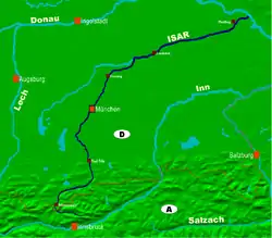


The Isar drains a substantial part of the Alps and parts of the Karwendel mountains northeast towards the Danube river and thus finally towards the Black Sea. Apart from the larger tributaries Amper and Loisach many smaller rivers empty into the Isar, such as the Leutasch, the Jachen, the Dürrach, the Dorfen, the Sempt, the Pfettrach and the Gleirschbach. The drainage basin contains some 9,000 square kilometers (3,500 square miles). During the winter most of the precipitation in the Alps falls as snow. This results in an increased water flow during the spring meltdown. It has an average discharge at the mouth of 174 m3/s (6,100 cu ft/s).[3] This makes it comparable to other medium-sized rivers in Germany, like the Moselle, Lech or Main.
The official head of the Isar is located in the Hinterau valley east of the village Scharnitz in the Karwendel mountains in Tyrol at a height above sea level of 1,160 metres (3,810 feet). In 2003 the Isar spring was “developed”, however, this move has been discussed due to environmental reasons. The Lavatschbach, which is the Isar’s longest headstream, has its source farther to the southeast near a mountain cabin named Hallangerhaus. It is also sometimes called the Isar’s head. Further on the young Isar is supplied water by the Birkkarbach, which has its source at the foot of the highest mountain of the Karwendel, the Birkkarspitze and the Moserkarbach.
Having entered Upper Bavaria after ca. 22 km (14 mi) just north of Scharnitz, the Isar is dammed for the first time between Mittenwald and Krün. Some of its waters are led via the Rißbach, whose flowing direction was reversed for this purpose, into the Walchensee. Here it is fed into the giant downpipes of the Walchensee power plant. 200 metres lower the plant releases this part of the water into the Kochelsee. From here it flows into the river Loisach, Isar's second most important tributary. Not far down the river a large reservoir called Sylvensteinsee was created between 1954 and 1959 to make more energy generation possible and also to avoid flooding. It is located some 12 km (7.5 mi) south of Lenggries. It has prevented some bad floods in Munich, for example in 1979, 1999 and most important, in 2005. In that year for the first time ever water had to be released from the lake because its capacity was exhausted. Flooding was barely avoided in Munich, literally 'by the width of one hand'. At Bad Tölz the Isar leaves the Bavarian Alps. This town marks the river's transit from its upper to its middle course.
It now flows through a sub-alpine, glacial morainic landscape towards Wolfratshausen. Just north of the town it absorbs the Loisach, including the water previously drained off for the power plant. The Isar continues on to and through the Munich gravel plain, into which it cuts a narrow, steeply sloped valley. The latter finally opens up and ends within the city limits of Munich. Further downstream the river passes Freising and then absorbs the waters of the Amper, its most important tributary, at Moosburg. This is where its lower course begins.
Passing Landshut, the river makes its way through the Tertiary Hills of Lower Bavaria all the way into the Danube valley. Its mouth at the Danube some five kilometres away from Deggendorf is at 312 metres (1,024 feet) above sea level. Thus the Isar descends some 848 metres (2,782 feet) from its head to its mouth.
History

Among Central European habitats, Alpine rivers are ranked among those most substantially altered by humans over the past hundred years. The Isar Rivers are now protected from development.[4]
At the lower Isar between Moosburg and Plattling gold was washed from the river’s sediments during the 16th and 17th century. However, there was no big economic revenue in this due to the minor amounts of the metal found in the river. Industrialization gave rise to a sociotechnical system were the Isar River was economically exploited through multifunctional use. Over forty hydropower plants were built on the Isar to electrify Bavaria.[5]
Following their executions on October 16, 1946, the ashes of the convicted Nazi war criminals Joachim von Ribbentrop, Hans Frank, Wilhelm Keitel, Alfred Jodl, Alfred Rosenberg, Ernst Kaltenbrunner, Wilhelm Frick, Arthur Seyss-Inquart, Fritz Sauckel and Julius Streicher were scattered in the Isar, as were those of Hermann Göring who had committed suicide the previous night in defiance of his scheduled execution.
In the 1940s and 1950s the federal state of Bavaria financed the construction of major hydroelectric power plants, the Sylvenstein reservoir on the Isar was constructed between 1954 and 1959.[6]
From 2000 till 2011 the Isarplan was implemented to reduce the risk of flooding. The planning and implementation was the responsibility of the Regional Office for Water Management and the city of Munich. Embankments were removed and the river bed was widened, establishing connections to surrounding flood plains. Riverbed rock ramps were constructed so that fish can move upstream again.[7]
Environmental issues

Since the 1920s the water of the Isar has been used for the generation of electricity. This has had far-reaching consequences not only for the local fauna and flora but also for people. To provide the 28 hydroelectric power plants with enough water power the river’s water is diverted several times and almost the whole river was canalized. For example, just north of Mittenwald all the river’s water was diverted to the lake Walchensee in 1923 for the Walchensee hydroelectric plant. Since 1990 a small portion of the water, 4 cubic meters per second (1100 U.S. gallons per second) is allowed to remain in the river to keep the area from being dry. The construction of the Sylvenstein Dam and numerous regulations relating to the river (pushed through in the early 19th century) have strongly enhanced its character. The construction of the Sylvenstein dam has prevented the river from overflowing its banks.
Lately, there have been attempts to bring the Isar closer back to a natural character. For example, since May, 2000, the river is being re-naturalized in the southern part of the river’s passage through the city of Munich, between Großhesseloher Brücke and Reichenbachbrücke. To achieve this the riverbed is being widened, the banks are flattened and small gravel islands are built along with near-natural ramps to slow the waterflow. Also, the dams are enlarged in width and height.
Besides an improved protection against flooding the river was, thus, brought into an almost natural state and this resulted in an improved quality of the recreational area within the city of Munich. The quality of the water has also improved due to the upgrading of the sewage plants along the river. The number of germs, however, is still relatively high. Together with other cities and communities along the Isar, Munich has set a goal to reduce the number of germs until the water quality is good enough to allow bathing in the river. If this is achieved, Munich would be one of the few big cities in Europe with a river with water of good enough quality to allow swimming in it. The sewer plants on the upper river are now treating the sewage with ultraviolet light, which greatly reduces the number of germs, but still the Isar cannot be guaranteed safe to bathe in because of the entrance of polluted rainwater into the river, especially during strong precipitation.
There are a number of natural reservations along the Isar, including special protection areas for birds, for example the natural reserve Vogelfreistätte Mittlere Isarstauseen northeast of Moosburg. This area is an important resting place for migrating water birds. There has been evidence for more than 260 different species of birds, among them rare species like the common tern and the bluethroat.
To preserve the beauty of the Isar valley Gabriel von Seidl founded the Isartalverein in 1902. This first civil initiative from Munich purchased 90 hectares (220 acres) of land, and today maintains more than 330 km (210 mi) of hiking trails.
Recreation
There are several areas along the river Isar that have been designated since the 1960s as nudist resorts. However, along much of its banks, even within the city of Munich, people can be seen skinny-dipping wherever they please.
Notes
References
- Complete table of the Bavarian Waterbody Register by the Bavarian State Office for the Environment (xls, 10.3 MB)
- Martin Bitschnau; Hannes Obermair (2009), Tiroler Urkundenbuch. II. Abteilung: Die Urkunden zur Geschichte des Inn-, Eisack- und Pustertals. Band 1: Bis zum Jahr 1140 (in German), Universitätsverlag Wagner, p. 25–27, ISBN 978-3-7030-0469-8
- "Danube River Basin District, Part A - Roof Report" (PDF). ICPDR. April 2004. p. 12.
- Christof Mauch; Thomas Zeller (2008). Rivers in History: Perspectives on Waterways in Europe and North America. University of Pittsburgh Press. p. 212. ISBN 9780822973416.
- Dieter Schott; Martin Knoll; Uwe Lubken, eds. (2017). Rivers Lost, Rivers Regained: Rethinking City-River Relations. University of Pittsburgh Press. ISBN 9780822981596.
- Christof Mauch; Thomas Zeller (2008). Rivers in History: Perspectives on Waterways in Europe and North America. University of Pittsburgh Press. p. 212. ISBN 9780822973416.
- Aletta Bonn; Horst Korn; Jutta Stadler; Nadja Kabisch, eds. (2017). Nature-Based Solutions to Climate Change Adaptation in Urban Areas. Springer International Publishing. p. 265. ISBN 9783319560915.
External links
| Countries |  | |
|---|---|---|
| Cities | ||
| Tributaries | ||
| Canals | ||
| See also | ||