Zemra Lake
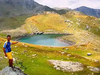
The Zemra Lake (Albanian: Liqeni i Zemrës) is a lake in the western edge of the Republic of Kosovo.[lower-alpha 1] Roughly in shape of a heart, the lake stretches inside the Prokletije, some 400 m (1,312 ft) away from Albania. It is situated between 2,200 and 2,500 metres of elevation above sea level on the northern slopes of Maja e Gusanit, near Maja e Gjeravicës.[1]

| Zemra Lake | |
|---|---|
 The lake within the alps. | |
 Zemra Lake  Zemra Lake  Zemra Lake | |
| Location | Prokletije Kosovo, Southern Europe |
| Coordinates | 42°31′49″N 20°7′14″E |
| Max. length | 150 m (490 ft) |
| Max. width | 120 m (390 ft) |
Notes
- The political status of Kosovo is disputed. Having unilaterally declared independence from Serbia in 2008, Kosovo is formally recognised as an independent state by 101 out of 193 (52.3%) UN member states (with another 13 recognising it at some point but then withdrawing their recognition), while Serbia continues to claim it as part of its own territory.
References
- Max Bosse, Kathrin Steinweg (2006). Peaks of the Balkans. München: Bergverlag Rother. p. 126. ISBN 978-3-7633-4491-8.
External links
 Media related to Zemra Lake at Wikimedia Commons
This article is issued from Wikipedia. The text is licensed under Creative Commons - Attribution - Sharealike. Additional terms may apply for the media files.