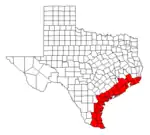
Texas Gulf Coast
Texas Gulf Coast is an intertidal zone which borders the coastal region of South Texas, Southeast Texas, and the Texas Coastal Bend. The Texas coastal geography boundaries the Gulf of Mexico encompassing a geographical distance relative bearing at 367 miles (591 km) of coastline according to CRS[1] and 3,359 miles (5,406 km) of shoreline according to NOAA.[2]
Texas Gulf Coast
Beaches of Texas | |
|---|---|
Texas Pictorials of Gulf of Mexico Coast | |
 Texas Coast Texas Marginal Seacoast | |
| Coordinates: 28.38477°N 96.38387°W | |
| Offshore water bodies | Gulf of Mexico |
| Area | |
| • Total | 2,149,760 acres (869,980 ha) |
| Dimensions | |
| • Length |
|
| Website | Texas Gulf Coast |


_(16656626391).jpg.webp)

Administrative divisions of Texas Gulf Coast

There are 14 Texas counties encompassing the Gulf of Mexico coastal boundary;
| Aransas | Kenedy |
| Brazoria | Kleberg |
| Calhoun | Matagorda |
| Cameron | Nueces |
| Chambers | Refugio |
| Galveston | San Patricio |
| Jefferson | Willacy |
Topography of Texas Gulf Coast
The Texas coastal bend sustains the Texas–Gulf water resource region as a hydrological cycle unifying a drainage basin of river deltas at the littoral zone of the Texas Gulf Coast.


Texas coastal management and impact resiliency
In accordance with the Coastal Zone Management Act and Coastal Barrier Resources Act, the Texas Gulf shores maintain a coastal management program striving to prohibit coastal erosion, coastal hazards, sea-level rise, and tidal flooding.[3] The Texas beach observed the initial coastal bulkhead and construction of the Galveston Seawall subsequently to the 1900 hurricane and 1915 hurricane levying a direct catastrophic impact at Galveston Island.[4][5] The Texas surf exemplifies a coastal defence with a seawall at North Padre Island, retaining wall at South Padre Island, and a revetment at Sargent Beach.
Imagery of Texas Early 20th Century Hurricanes
| ☆ |
| ☆ |
Texas Gulf Bays and Coastal Waterways
The Texas gulf coast has a geography of ten coastal bays and bountiful with waterway inlets;
| Aransas Bay | Lavaca Bay |
| Baffin Bay | Matagorda Bay |
| Copano Bay | Redfish Bay |
| Corpus Christi Bay | San Antonio Bay |
| Galveston Bay | South Bay |
Waterway inlets of Texas Barrier Islands

The Texas coastal bend has a geography of waterways fringed by the Texas barrier islands. The Texas seacoast is collectively multitudinal with navigable straits traversing watercraft access as a concourse to the Gulf Intracoastal Waterway and the Texas estuaries.[6][7]
| ☆ Aransas Pass | ☆ Freeport Harbor Channel 28.93600°N 95.29645°W |
| ☆ Bolivar Roads | ☆ Matagorda Ship Channel |
| ☆ Brazos River Delta 28.87855°N 95.38028°W | ☆ Packery Channel 27.61440°N 97.20082°W |
| ☆ Brazos Santiago Pass | ☆ Port Mansfield Channel |
| ☆ Caney Creek Pass 28.75305°N 95.65828°W | ☆ Rollover Pass |
| ☆ Cavallo Pass | ☆ Sabine Pass |
| ☆ Cedar Bayou Pass 28.06381°N 96.85091°W | ☆ San Bernard River Pass 28.85207°N 95.44075°W |
| ☆ Cedar Lakes Pass 28.81875°N 95.52153°W | ☆ San Luis Pass |
| ☆ Colorado River Delta 28.59187°N 95.98328°W | ☆ Spring Bayou Pass 28.61242°N 95.94006°W |
| ☆ Fish Pass 27.67695°N 97.16578°W | ☆ Sunday Beach Pass 28.35992°N 96.39941°W |
National and state parks of Texas Gulf Shores

The Texas Parks and Wildlife Department oversees the Texas state parks located on the Gulf of Mexico shores with the exception of Padre Island seashore which is maintained by the National Park Service.
| Galveston Island State Park | Padre Island National Seashore |
| Goose Island State Park | Resaca de la Palma State Park |
| Mustang Island State Park | Sea Rim State Park |
Nature sanctuaries of Texas Coastal Zones
The United States Fish and Wildlife Service governs the nature reserves as land parcels of the National Wildlife Refuge System bordering the Texas coastal zones.[8]
Antiquity of Texas Gulf Coast
European Colonization of Texas Coast


North American expeditions and exploratory endeavors emerged with the europeans engaging their efforts for transatlantic crossings during the late fifteenth century.[11]
Exploration of Spanish Conquistador
The Texas marginal seacoast acknowledged the arrival or entradas of Álvar Núñez Cabeza de Vaca during the first quarter century of the 1500s.[12] Cabeza de Vaca, a Spanish conquistador and a successor of Christopher Columbus, embarked on a calamitous coastal ship landing near the shore of Galveston Island on November 6, 1528.[13][14][15]
New Spain economic currency and perils of Spanish Sea
In 1554, a Spanish cargo ship known as the San Esteban was tacking from Veracruz due north along the Texas Gulf Coast with an eastern destination at Havana and the West Indies.[16][17] The New Spain galleon encountered a severe tropical cyclone in the Spanish Sea proximate the 27th parallel north and 97th meridian west decimating the Spanish treasure fleet known as Espiritu Santo, San Estaban, and Santa Maria de Yciar.[18] The shipwreck derelict is entitled as a National Register of Historic Places.[19][20] The underwater archaeology site was established as the Mansfield Cut Underwater Archeological District at Padre Island National Seashore in 1974.[21][22]
Expedition of France Monarchy
The Texas oceanic basin was colonized by the France monarchy or Louis XIV from 1684 to 1689. In 1684, Robert Cavelier de La Salle sailing under the French ensigns guided an expedition in the Spanish Sea of four ships known as L'Aimable, La Belle, Le Joly, and St. François.[23] La Salle and Henri de Tonti were pursuing the Mississippi River Delta seeking to discover the French colonial empire of New France. In 1685, La Salle navigated beyond the Atchafalaya Basin and lower Mississippi River basin inaccurately discovering Matagorda Bay where the French cargo vessels anchored near Indianola, Texas.[24][25] During 1685 to 1689, the La Salle colonists adventured north of Lavaca Bay establishing a land settlement known as Fort St. Louis near Garcitas Creek and Inez, Texas ratifying the French colonization of Texas.[26][27][28][29]
Spanish Empire and Transformation of North Americas
The Texas Gulf coast attested to a second wave of the European colonization of the Americas with the introduction of colonialism by the Spanish Empire in 1690.[30] The España cultural evolution substantiated a christianization or religious conquest by the transatlantic crossing of the Spanish Inquisition.[31][32] The España colonization established the Viceroyalty of New Spain administratively structuring an interior province known as Spanish Texas from 1690 to 1821.[33] Beginning in 1810, the Mexican War of Independence was settled with the Spanish Empire ennobling a discontinuation of the Mexican Inquisition while creating the First Mexican Empire in 1821.
19th Century of Texas Gulf Coast
French Corsairs of Gulf Waters and Texas Shores
The Texas Gulf coast served as a sanctuary for seafaring buccaneers, corsairs, privateers, and non-fictional practitioners of the piracy occupation. Galveston Bay and Matagorda Bay were the Texas coast fertile crescent for anchorage and concealment of the barque, barquentine, and brigantine class sailing vessels.[34]

In the early nineteenth century, Jean Lafitte and Pierre Lafitte, kinship of french basque and sea-going privateers, managed a modest metal forging establishment known as the Lafitte's Blacksmith Shop in the New Orleans French Quarter. In 1807, the 10th United States Congress passed the Embargo Act of 1807 coercing the displacement of the Lafitte's venture to Barataria, Louisiana settled south of New Orleans within the Mississippi River Delta region.[35]
By 1808, the Lafittes' discovered brigandage to be an invaluable endeavor smuggling pirate booty from Barataria Bay to New Orleans.[36] In 1814, the United States Navy launched a naval offensive on the Baratarian's prize of war enterprise debilitating the Lafitte's French corsair sailing fleet.[37]
After the remnants of the War of 1812, Jean Lafitte departed Grand Terre Island and the wetlands of Louisiana setting the sails for Galveston Island, Texas.[38] In early 1817, freebooter Jean Lafitte established a piracy colony at Galveston Island.[39] Frenchman Lafitte constructed his Maison Rouge residence perpendicular of the Galveston Channel and Pelican Island with the surroundings of a corsair's piracy settlement.[40] The Brethren of the Coast discovered the Galveston landscape to be conducive for passage to the gulf waters supporting sailing ship tactics to intercept merchant ships and Spanish Empire armadas accomplishing the nautical journey from the Old World.[41]
After the Galveston Hurricane of 1818, French privateer Lafitte abandoned Galveston Bay for the Bay of Campeche beseeching safe conduct at the cays of Campeche Bank.[42][43][16] By 1821, the Texas seacoast exodus was resolutely coerced by the authorization of the 15th United States Congress legislative article known as the Piracy Suppression Act of 1819 enacted into law by United States President James Monroe on March 3, 1819.[44][45]
In 1814, Lord Byron authored a poetic publication The Corsair which was conceivably an attribute to the life of Jean Lafitte.[46] In 1927, Galveston's William Moody Jr. erected the Jean Lafitte Hotel in the Galveston's Strand Historic District as an observance of privateer Lafitte's origins on the Galveston Island shores.[47][48]
Mexico Governance, Texas Revolution, and Republic of Texas
Texas revered the first glance of the Texas Revolution with the Fredonian Rebellion occurring from 1826 to 1827 in the East Texas vicinity of Nacogdoches, Texas.[49]
After the conflict of cultural imperialism ceased between Mexico and Spain, the Law of April 6, 1830 and Treaty of Limits furthered the successive uniformity known as Mexican Texas from 1828 to 1836.[50][51][52]
In 1836, Texas independence was expeditiously declared from the imperialism of Mexico subsequently to the San Felipe de Austin and Texian Consultation events;
| ☆ Captivity of Antonio López de Santa Anna at Galveston Bay |
| ☆ Cessation of the Battle of San Jacinto at Galveston Bay |
| ☆ Convention of 1836 at Washington-on-the-Brazos |
| ☆ Endorsement of Texas Declaration of Independence and Constitution of the Republic of Texas |
| ☆ Repeal of 1824 Constitution of Mexico |
| ☆ Treaties of Velasco at Fort Velasco |
| ☆ Armistice of 1843 and peace negotiations with Mexico[53] |
and the forthcoming establishment and separation of powers for the Republic of Texas.[54][55]
Mexican State Naval Operations and Texas Gulf Coast
The Texas Gulf Coast provided a naval supply lifeline for the Texian Army and Texian Militia during the Texas Revolution sustaining from 1835 to 1836. The Texian Navy sustained the Texian revolutionary infantry forces by providing a flotilla for the safe passage of munitions and supply provisions.[56] The Mobile and New Orleans harbors routing merchant ships defined a vast maritime area for the Texas Navy skirting the Texas seacoast while surveilling the Mexican state nautical hostilities and naval warfare on the Third Coast.[57]
The Mexican Navy enforced coastline patrols and naval blockades of the Texas Gulf Coast harbors during the strife for Texas independence. The Texas naval forces appropriated four man-of-war schooners as a naval offensive for the sailing ship tactics of the Mexican Navy. The Texas Navy engaged four warships from 1835 to 1838 known as Brutus, Independence, Invincible, and Liberty for the establishment of the Republic of Texas and decisively the Texas annexation on December 29, 1845.[58]
Infectious Disease Epidemic and Texas Seacoast
In 1860s, the Texas coastal counties encountered a disease vector which inflicted an arbovirus on the Texas ocean front townships.[59][60] The pathogen transmission was potentially infiltrating the trade ports through merchant ships, nautical vessels, and seafaring watercraft along the Texas coastline.[61] The predatorial Aedes aegypti yield a mosquito-borne disease aggressively disseminating an infection known as yellow fever on the South Texas civil parishes from the nineteenth century to the early twentieth century.[62][63]
| Texas Historic Preservation Sites by Texas Historical Commission |
| ◇ "Galveston Quarantine Stations – Galveston County ~ Marker Number: 7474". Texas Historic Sites Atlas. Texas Historical Commission. 1993. |
| ◇ "Yellow Fever Epidemic of 1862 – Matagorda County ~ Marker Number: 18121". Texas Historic Sites Atlas. Texas Historical Commission. 2015. |
| ◇ "Huntsville Yellow Fever Epidemic of 1867 – Walker County ~ Marker Number: 18491". Texas Historic Sites Atlas. Texas Historical Commission. 2016. |
| ◇ "Yellow Fever Epidemic of 1867 – Fayette County ~ Marker Number: 18523". Texas Historic Sites Atlas. Texas Historical Commission. 2016. |
United States National Security of Texas Gulf Coastline
The Texas Gulf coast had a vital necessity for seacoast defense as the international relations of superiority cultivated during the late 19th century to the mid-20th century. The United States artillery installations were erected during the Spanish–American War frequently referred as Cuban War of Independence, and relatively to the world war periods of the 1910s and 1940s.
The Texas coastal artillery command posts were established as casemates or pillboxes developed with reinforced concrete strategically situated at Bolivar Peninsula, Texas and Galveston Island, Texas. The United States Army Coast Artillery Corps commanded the operations of the coastal artillery emplacements which originated as Fort Crockett, Fort San Jacinto, Fort Travis, and inclusion of Sabine Pass.[64][65][66] The artillery fortifications achieved the purposes of economic warfare or embargo for Galveston Bay, vigilance of maritime security, and safeguarding the trade routes for Port of Galveston and the Port of Houston.[67]
Imagery of Texas Gulf Coast Fortress Installations
| ☆ |
| ☆ |
| ☆ |
| ☆ |
See also
References
- "U.S. International Borders: Brief Facts", Congressional Research Service, November 9, 2006
- "Shoreline Mileage of the United States" (PDF). NOAA Office for Coastal Management. National Oceanic and Atmospheric Administration.
- "Texas Coastal Management Program". The Texas General Land Office. State of Texas.
- "1900 Storm". Galveston & Texas History Center. Rosenberg Library.
- "1915 Storm". Galveston & Texas History Center. Rosenberg Library.
- "Gulf Intracoastal Waterway – Brazoria County ~ Marker Number: 9564". Texas Historic Sites Atlas. Texas Historical Commission. 1967.
- "Corpus Christi and the Gulf Intracoastal Waterway – Nueces County ~ Marker Number: 17184". Texas Historic Sites Atlas. Texas Historical Commission. 2012.
- "Texas Coastal Zone Boundaries" (PDF). The Texas General Land Office. State of Texas.
- "La Salle Monument – Calhoun County ~ NRHP Number: 100002757". Texas Historic Sites Atlas. Texas Historical Commission. July 27, 2018.
- "Rene Robert Cavelier Sieur de la Salle" [Indianola in Calhoun County, Texas - The American South (West South Central)]. HMDB.org. The Historical Marker Database.
- "European Exploration and Development" [European Exploration of North America and What is Now Texas Began in the 15th Century]. Texas Almanac. Texas State Historical Association (TSHA).
- Thoms, Alston V. "Learning From Cabeza De Vaca". Texas Beyond History. University of Texas at Austin.
- "Karankawa Campsite – Galveston County ~ Marker Number: 7502". Texas Historic Sites Atlas. Texas Historical Commission. 1966.
- "West Galveston Island – Galveston County ~ Marker Number: 11591". Texas Historic Sites Atlas. Texas Historical Commission. 1967.
- "West Galveston Island" [Galveston in Galveston County, Texas - The American South (West South Central)]. HMDB.org. The Historical Marker Database.
- Popple, Henry (1733). "Gulf of Mexico, Bay of Campeche". LOC Maps. United States Library of Congress. LCCN 2009582407.
- Arnold III, J. Barto; Wickman, Melinda Arceneaux. "Padre Island Spanish Shipwrecks of 1554". Handbook of Texas Online. Texas State Historical Association.
- "Santa Maria de Yciar, San Esteban, Espiritu Santu". Raymondville in Willacy County, Texas – The American South (West South Central). The Historical Marker Database.
- "Mansfield Cut Underwater Archeological District ~ NRHP 74002083". National Park Service. U.S. Department of the Interior. January 21, 1974.
- "Mansfield Cut Underwater Archeological District ~ NRL 2074002083". Texas Historic Sites Atlas. Texas Historical Commission. January 21, 1974.
- "Photograph of a Historic Property in Texas" [Artifacts from 1554 Shipwreck at Mansfield Cut Archeological District]. University of North Texas Libraries ~ The Portal to Texas History. Texas Historical Commission.
- "Photograph of a Historic Property in Texas" [Diver Investigating 1554 Shipwreck at Mansfield Cut Archeological District]. University of North Texas Libraries ~ The Portal to Texas History. Texas Historical Commission.
- Weddle, Robert S. "La Salle Expedition". Handbook of Texas Online. Texas State Historical Association.
- "Rene Robert Cavelier, Sieur de la Salle – Calhoun County ~ Marker Number: 4243". Texas Historic Sites Atlas. Texas Historical Commission. 1936.
- "Indianola – Calhoun County ~ Marker Number: 2642". Texas Historic Sites Atlas. Texas Historical Commission. 1963.
- "Fort St. Louis – Victoria County ~ Marker Number: 2020". Texas Historic Sites Atlas. Texas Historical Commission. 1936.
- "Fort St. Louis – Victoria County ~ NRHP Number: 71000969". Texas Historic Sites Atlas. Texas Historical Commission. March 31, 1971.
- "Fort St. Louis". Texas Beyond History. University of Texas at Austin.
- Weddle, Robert S. "La Salle's Texas Settlement". Handbook of Texas Online. Texas State Historical Association.
- Joseph, Harriett Denise; Chipman, Donald E. "Spanish Texas". Handbook of Texas Online. Texas State Historical Association.
- Faulk, Odie B. "Presidios". Handbook of Texas Online. Texas State Historical Association.
- Wright, O.M.I., Robert E. "Spanish Missions". Handbook of Texas Online. Texas State Historical Association.
- Weddle, Robert S. "Spanish Mapping of Texas". Handbook of Texas Online. Texas State Historical Association.
- "Barque At Galveston Wharf Pier". Rosenberg Library Museum. Galveston & Texas History Center.
- Warren, Harris Gaylord. "Laffite, Jean". Handbook of Texas Online. Texas State Historical Association.
- "Jean Lafitte: History & Mystery". National Park Service. U.S. Department of the Interior.
- "Bronze statue of Jean Lafitte". Rosenberg Library Museum. Galveston & Texas History Center.
- "Lafitte's Grove – Galveston County ~ Number: 7509". Texas Historic Sites Atlas. Texas Historical Commission. 1936.
- "Jean Lafitte – Galveston County ~ Marker Number: 7508". Texas Historic Sites Atlas. Texas Historical Commission. 1965.
- "Maison Rouge, Galveston". Rosenberg Library Museum. Galveston & Texas History Center.
- "Jean Lafitte's Headquarters". Rosenberg Library Museum. Galveston & Texas History Center.
- Geiser, S.W. "Racer's Storm (1837), With Notes On Other Texas Hurricanes In The Period 1818–1886" [Field and Laboratory: Contributions from the Science Departments, Volume 12, Number 2 (1944)]. Field and Laboratory ~ SMU Scholar. Southern Methodist University. pp. 59, 64.
- Dunn, Roy Sylvan. "Hurricanes". Handbook of Texas Online. Texas State Historical Association.
- Fifteenth Congress (February 24, 1819). "Anti-Piracy Act of 1819 ~ U.S. Senate Approval". Journal of the Senate of the United States of America, 1789–1873. U.S. Library of Congress. VIII (Wednesday, February 24, 1819): 303.
- Fifteenth Congress (March 1, 1819). "Anti-Piracy Act of 1819 ~ U.S. House of Representatives Approval". Journal of the House of Representatives of the United States. U.S. Library of Congress. XII (Monday, March 1, 1819): 329.
- Byron, George Gordon (1814). "The Corsair: A Tale". Internet Archive. London, United Kingdom: Thomas Davidson, Whitefriars.
- "Jean Lafitte Hotel – Galveston County ~ NRHP Number: 84001705". Texas Historic Sites Atlas. Texas Historical Commission. August 14, 1984.
- "Jean Lafitte Hotel". National Park Service. U.S. Department of the Interior.
- McDonald, Archie P. "Fredonian Rebellion". Handbook of Texas Online. Texas State Historical Association.
- Bishop, Curtis. "Law of April 6, 1830". Handbook of Texas Online. Texas State Historical Association.
- Fagoaga, Francisco (December 1, 1832). "Treaty of Limits ~ January 12, 1828". University of North Texas Libraries ~ The Portal to Texas History. Star of the Republic Museum.
- de León, Arnoldo; de la Teja, Jesús "Frank". "Mexican Texas". Handbook of Texas Online. Texas State Historical Association.
- "Republic of Texas ~ Negotiating for Peace With Mexico". Republic of Texas Online Exhibit. Texas State Library and Archives Commission.
- "Republic of Texas ~ The Archives War of 1842". Republic of Texas Online Exhibit. Texas State Library and Archives Commission.
- "Texas State Law – Chapter 91 ~ Capitol for the State of Texas" [The Laws of Texas, 1822–1897 – Volume 3]. The Portal to Texas History. University of North Texas Libraries. February 14, 1852. pp. 978–982.
- "Fortune Favors the Brave - The Story of the Texas Navy". Texas State Library ~ Exhibits. Texas State Library and Archives Commission.
- "Galveston in the Republic of Texas – Galveston County ~ Number: 7457". Texas Historic Sites Atlas. Texas Historical Commission. 1965.
- "First Navy of the Republic of Texas – Galveston County ~ Number: 7537". Texas Historic Sites Atlas. Texas Historical Commission. 1936.
- Doleshal, PhD, Zachary. "The Yellow Fever Epidemic of 1867". East Texas History. Sam Houston State University.
- Burns, Chester R.; Wooten, Heather Green. "Epidemic Diseases". Handbook of Texas Online. Texas State Historical Association.
- Anonymous. "Ocean Shipping". Handbook of Texas Online. Texas State Historical Association.
- "Livingston Lindsay to Texas Governor Elisha M. Pease, October 9, 1867" [Letter on the Devastating Yellow Fever Epidemic in La Grange]. Portraits of Texas Governors ~ War, Ruin, and Reconstruction Part II, 1866–1876. Texas State Library and Archives Commission.
- Bernstein, Robert. "Public Health". Handbook of Texas Online. Texas State Historical Association.
- Darst, Maury. "Fort Crockett". Handbook of Texas Online. Texas State Historical Association.
- Darst, Maury. "Fort San Jacinto". Handbook of Texas Online. Texas State Historical Association.
- Darst, Maury. "Fort Travis". Handbook of Texas Online. Texas State Historical Association.
- "Galveston: Gateway to Texas – Galveston County ~ Marker Number: 7460". Texas Historic Sites Atlas. Texas Historical Commission. 1965.
- "Fort Travis – Galveston County ~ Marker Number: 7452". Texas Historic Sites Atlas. Texas Historical Commission. 1993.
- "Spanish-American War Fortifications ~ Jefferson County – Marker Number: 10568". Texas Historic Sites Atlas. Texas Historical Commission. 1983.
Bibliography
| ☆ Weddle, Robert S. (1985). Spanish Sea: the Gulf of Mexico in North American Discovery, 1500–1685. College Station, Texas: Texas A&M University Press. ISBN 978-1585440665. OCLC 11468026. |
| ☆ Weddle, Robert S. (1991). The French Thorn: Rival Explorers in the Spanish Sea, 1682-1762. College Station, Texas: Texas A&M University Press. ISBN 978-0890964804. OCLC 23286547. |
| ☆ Weddle, Robert S. (1995). Changing Tides: Twilight and Dawn in the Spanish Sea, 1763-1803. College Station, Texas: Texas A&M University Press. ISBN 978-0890966617. OCLC 32202575. |
| ☆ Francaviglia, Richard V. (1998). From Sail to Steam: Four Centuries of Texas Maritime History, 1500-1900. Austin, Texas: University of Texas Press. ISBN 978-0292723054. OCLC 36548957. |
| ☆ Davis, William C. (2006). The Pirates Laffite: The Treacherous World of the Corsairs of the Gulf. Orlando, Florida: Houghton Mifflin Harcourt. ISBN 978-0547350752. OCLC 68570266. |
| ☆ Williams, C. Herndon (2010). Texas Gulf Coast Stories. Charleston, South Carolina: Arcadia Publishing. ISBN 978-1614232469. OCLC 664519681. |
| ☆ Winningham, Geoff (2010). Traveling the Shore of the Spanish Sea: the Gulf Coast of Texas and Mexico. College Station, Texas: Texas A & M University Press. ISBN 978-1603441612. OCLC 613354738. |
| ☆ McDougal, Steph (2014). Lighthouses of Texas ~ Images of America. Charleston, South Carolina: Arcadia Publishing. ISBN 978-1531675660. OCLC 858731310. |
| ☆ Blackburn, James B.; Galveston Bay Conservation & Preservation Assn. (2015). The Book of Texas Bays. College Station, Texas: Texas A&M University Press. ISBN 978-1603447829. OCLC 907399500. |
| ☆ Lardas, Mark (2016). Texas Shipwrecks ~ Images of America. Charleston, South Carolina: Arcadia Publishing. ISBN 978-1467116176. OCLC 930257191. |
| ☆ Lardas, Mark (2021). The Vanished Texas Coast: Lost Port Towns, Mysterious Shipwrecks, and Other True Tales. Charleston, South Carolina: The History Press. ISBN 978-1540248619. OCLC 1252763669. |
Periodical Publications
| ☆ Harrigan, Stephen (January 1979). "In Search of La Salle". Texas History. Texas Monthly. |
| ☆ Tyer, Brad (September 1996). "Dig This" [A salvage operation in Matagorda Bay unearths a bureaucratic feud]. Texas History. Texas Monthly. |
| ☆ Dingus, Anne (November 2002). "Lights Out". Texas History. Texas Monthly. |
| ☆ Gustavus, Sarah (November 2002). "Texas History 101" [Half Moon Reef Lighthouse served as a beacon for ships coming into Matagorda Bay]. Texas History. Texas Monthly. |
| ☆ Harrigan, Stephen (March 2017). "They Came From the Sky" [The first Spanish conquistadors arrive on our shores, starving, haggard, and in no mood for conquest]. Texas History. Texas Monthly. |
| ☆ Berwald, Juli (September 2021). "Behind the Fight to Save the Gulf's Spectacular Coral Reefs". Texas Travel & Outdoors. Texas Monthly. |
Texas Coastal Science
- "Bays and Estuaries". Texas Aquatic Science. Texas Parks and Wildlife Department.
- "Coastal Conservation". Audubon Texas. National Audubon Society.
- "Gulf Coast". Education ~ Resources. Texas Parks and Wildlife Department.
- "Oceans: The Gulf of Mexico". Texas Aquatic Science. Texas Parks and Wildlife Department.
- "Red Tide in Texas". TPWD Harmful Algal Blooms Status. Texas Parks and Wildlife Department.
- "Texas Beach Watch". Texas General Land Office. U.S. Environmental Protection Agency.
- "USGS Texas Coastal Science". USGS Oklahoma-Texas Water Science Center. U.S. Department of the Interior.
- "Wetlands". Texas Aquatic Science. Texas Parks and Wildlife Department.
External links
 Media related to Bays of Texas at Wikimedia Commons
- Media related to Beaches of Texas at Wikimedia Commons
- Media related to Estuaries in Texas at Wikimedia Commons
- Media related to Texas Coast at Wikimedia Commons
 Gulf Coast (Texas) travel guide from Wikivoyage
| Management |  | |
|---|---|---|
| Hard engineering | ||
| Soft engineering | ||
| Related topics | ||
| By period | |
|---|---|
| By topic | |
| By city |
|
| Government agency | |