Glauberg
The Glauberg is a Celtic hillfort or oppidum in Hesse, Germany consisting of a fortified settlement and several burial mounds, "a princely seat of the late Hallstatt and early La Tène periods."[1][2] Archaeological discoveries in the 1990s place the site among the most important early Celtic centres in Europe. It provides unprecedented evidence on Celtic burial, sculpture and monumental architecture.
 The "Prince of Glauberg" (5th century BC) | |
 Shown within Hesse  Glauberg (Germany) | |
| Location | Glauburg, Hesse |
|---|---|
| Region | Germany |
| Coordinates | 50°18′19″N 9°00′31″E |
| Type | Burial mounds, Circular rampart or Oppidum |
| History | |
| Periods | Iron Age |
| Cultures | Celts, Urnfield culture, Hallstatt culture, La Tène |
| Site notes | |
| Public access | Yes |
Location and topography
Geologically, the Glauberg, a ridge (271 m asl) on the east edge of the Wetterau plain, is a basalt spur of the Vogelsberg range. Rising about 150 m above the surrounding areas, it is located between the rivers Nidder and Seeme and belongs to the community of Glauburg. The hilltop forms a nearly horizontal plateau of 800 by 80–200m. Its southwest promontory is known as Enzheimer Köpfchen. To the northwest, the Glauberg slopes steeply down towards the Nidder valley and, in the south, it is connected with undulating uplands. The plateau contained a small perennial pond, which was not fed by springs but simply by surface runoff.[3] The hill is surrounded by springs and fertile land.[4]
History of archaeological research
The presence of ancient ruins on the Glauberg plateau has long been known, though they were credited to the Romans. The discovery of a fragment of an early La Tène torc in 1906 confirmed the prehistoric nature of the site. Systematic archaeological research began in 1933–1934 with an excavation led by Heinrich Richter (1895–1970) which focused on the fortification.[5] Further studies directed by F.-R. Hermann began in 1985 and continued until 1998. It was during this phase that the important burial mound was examined.[6] The settlement history of the Glauberg and its area in Celtic times (Hallstatt and early La Tène periods) was the focus of a research project (2004–2006) by the 'Deutsche Forschungsgemeinschaft'.[7]
Excavations continue into the present day with a multinational team excavating what is believed to be a former massive rampart at the hillfort that is currently only visible through lidar.
 Gold Celtic torc found in the larger tumulus at Glauberg, 400 BC
 La Tène period sword and ornaments, Glauberg museum
Summary of settlement history


The topographic location marks the Glauberg as a long-term focus of human activity. It combines access to fertile arable land and water with an easily defensible site and a strategic location along several natural traffic routes. Thus, it is not surprising that the hill was the site of human occupation long before and long after its Celtic phase, well into the medieval period.[8]
The Glauberg plateau was first settled in the Neolithic era (c. 4500 BC) by people of the Rössen culture. This was followed by a large settlement of the Michelsberg phase (4000 BC). Michelsberg hilltop fortifications are known elsewhere, so it is possible that the hill was fortified for the first time at that stage. The hill was also settled by the late Bronze Age Urnfield culture (1,000–800 BC). During the Celtic late Hallstatt/early La Tène period, the Glauberg became a centre of supra-regional importance. At this time, it was the seat of an early Celtic prince. Extensive fortifications were erected.
During the Roman occupation of Germany, the Glauberg remained unoccupied, probably due to its proximity (5 km) to the fortified Limes Germanicus border. In the 4th and 5th centuries AD, it was reoccupied and became a regional centre once again, as the seat of a local king of the Alamanni. From the 7th to the 9th century, it was the site of a large Frankish fortification. Its importance grew throughout this time, and the fortifications were renewed and extended considerably.
In the 12th and 13th centuries, the Glauberg was incorporated into the Staufer system of castles, perhaps in an attempt to foster the growth of an urban centre. The fortifications were renovated again, and a tower-like castle was erected on the edge of the plateau; its arched romanesque doorway survives. The whole plateau was settled at this time, medieval foundations of walls, wells and basements survive especially at its north edge. The destruction of that castle, and with it the end of human occupation on the hill, probably occurred in 1256.
Celtic oppidum
.jpg.webp)

The earliest known fortifications might be pre-Celtic, but they reached a high point in terms of size and elaboration around the 6th or 5th century BC. They remained in use until the 2nd or 1st century BC. Their extent and dimensions mark the Glauberg as one of a network of fortified sites (or oppida) that covered most of south and west central Germany.
The northeast edge of the hill, where the slope is least severe, was disconnected from the adjacent ground by the erection of a massive ditch and bank, perhaps originally forming a promontory fort. The southern and northern edges were also fortified with walls. The walling techniques included drystone walling, the murus gallicus (a typical Celtic technique of wood and stone) and perhaps also mudbrick.

The small hilltop pond would not have sufficed to ensure water supply for the population of so large a settlement. For this reason, an annex was added to the north, with two walls running downslope, enclosing an additional triangular area of 300 x 300 m, including a spring. The point of that annex contained a huge water reservoir, measuring 150 by 60 m. At this time, the fortification was 650 m long, nearly 500 m wide, and enclosed an area of 8.5 ha.
At least two gates, a main one to the northeast and a smaller one to the south, gave access to the interior. They are fairly complex in shape, designed to make access for a possible attacker more difficult. An outer fortification was placed beyond the northeast edge of the oppidum. Walls or banks to the south probably played no defensive role.[9]
Such settlements probably housed populations numbering in the thousands. For this reason, combined with their centralising economic role, Celtic oppida are sometime described as proto-urban. Nonetheless, little is known about settlement and other activity on the interior of the site. Evidence from the sites at Manching or Oberursel-Oberstedten suggests that there was probably a village or town-like settlement with houses, workshops and storage areas.
Sites associated with the oppidum
Like other such sites, the Glauberg oppidum is connected with several other contemporary sites/complexes in its immediate vicinity:
"Princely" burial mounds

During an exploratory overflight in 1988, local amateur historians recognised the traces of a large tumulus in a field 300 m south of the oppidum. Between 1994 and 1997, the State Archaeological Service of Hesse excavated it.[10] The mound (mound 1) originally had a diameter of nearly 50 m and a height of 6 m. It was surrounded by a circular ditch 10 m wide. At the time, it must have been a visually extremely striking monument. The tumulus contained three features. An empty pit was placed at the centre, perhaps to mislead potential looters. To the northwest, a wooden chamber of 2 x 1 m contained an inhumation, and to the southeast, a cremation burial had been placed in some kind of wooden container. Cremations are more commonly associated with the Halstatt phase, inhumation with the La Tène one.
The occupants of both graves were warriors, as indicated by their accompanying material: swords and weaponry. The chamber with the inhumation was extremely well preserved and had never been looted. For this reason, it was decided to remove the whole chamber en bloque and excavate it more slowly and carefully in the State Service laboratory at Wiesbaden. The finds from the main burial chamber, each carefully wrapped in cloth, include a fine gold torc and a bronze tubular jug that had contained mead.
A second tumulus (mound 2), 250 m to the south, was discovered later by geophysical survey. Erosion and ploughing had made it totally invisible. About half the size of mound 1, it also contained a warrior, accompanied by weapons, a decorated fibula and belt, and a gold ring.
The high quality of the tomb furnishings as well as other features associated with them indicate that the graves, and their occupants, were of extremely high status. They are therefore classed as "princely" burials, on a par with other well-known finds, including those at Vix (Burgundy, France), and Hochdorf (Baden-Württemberg, Germany).
Earthworks and processional road

A number of earth features (banks and ditches) are located south of the oppidum, some closely associated with mound 1. They appear to play no defensive role. A small square ditch west of the mound is associated with several other features and a number of large postholes, perhaps suggesting a shrine or temple. Most strikingly, a processional way 350 m long, 10 m wide and flanked by deep ditches approached the tumulus from the southeast, far beyond the settlement perimeter. This was associated with further banks and ditches extending over an area of nearly 2 by 2 km. They also contained at least two burials, as well as the statue described below.
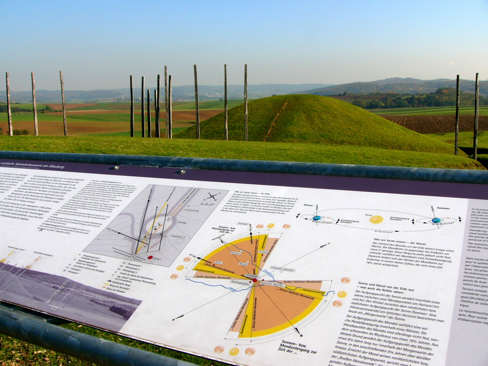
Possible calendar function
The lack of a defensive function and the focus on the burial mounds have led to the suggestion that the enclosure and road system had a ritual or sacred significance.
Posluschny (2007, 2019) found that the processional road is aligned to the point of the major lunar standstill at moonrise, which occurs once every 18.6 years. The astronomical knowledge required to create such an alignment would have required long-term observation of the skies, possibly over several generations. Posluschny suggests that a precursor to the processional road may date back to the Late Bronze Age.[11][12]
Further analyses have indicated that other ditches and postholes associated with the burial mound could have been used to observe different astronomical phenomena, such as the solstices, with the whole ensemble functioning as a calendar.[13][14][15] A calendar function has also been proposed for the earlier Magdalenenberg burial mound.[16]
The Keltenfürst (Celtic prince) of Glauberg


Much international attention was attracted especially by the discovery of an extremely rare find, a life-sized sandstone statue or stele, dating from the 5th century BC, which was found just outside the larger tumulus.[17] The stele, fully preserved except for its feet, depicts an armed male warrior. It measures 186 cm in height and weighs 230 kg.[18]: 68 It is made from a type of sandstone available within a few kilometres of Glauberg. Much detail is clearly visible: his trousers, composite armour tunic, wooden shield and a short sword in a scabbard with an anthropomorphic hilt (of La Tène style), hanging from his right side. The moustachioed man wears a torc with three pendants, remarkably similar to the one from the chamber in mound 1, several rings on both arms and one on the right hand. On his head, he wears a "leaf crown", or hood-like headdress crowned by two protrusions, resembling the shape of mistletoe leaves. Such headdresses are also known from a handful of contemporary sculptures, and coins. As mistletoe is believed to have held a magical or religious significance to the Celts, it could indicate that the individual depicted also played the role of a priest or druid.[19] Short swords similar to that depicted on the statue have been found across central and western Europe, with lunar symbols on their blades that are thought to represent different stages of the lunar cycle, or lunar eclipses.[20][21] These have been associated by researchers with a priestly class, or druids, who possessed calendrical and astronomical knowledge.[22][23] Similarities between these lunar symbols and the later Coligny calendar, thought to be a druidic calendar, have also been suggested.[24]
The remains of a similar mistletoe-shaped 'leaf crown' have been found at Fiskerton in England, at the site of a wooden causeway dating from c. 450 to 300 BC which was used to make ritual depositions into the Witham river.[25] Dating of the causeway timbers has shown that they were felled at intervals corresponding to lunar eclipses, indicating that the builders of the causeway had a knowledge of Saros lunar eclipse cycles.[26][27] A short sword with an anthropomorphic hilt and a lunar crescent symbol on its blade was also found near by.[28] Similar evidence from other sites in Wales, Germany, Switzerland and Ireland suggests that knowledge of eclipse cycles and associated timber-building practices may date back to c. 1000 BC or earlier, showing continuity from the Bronze Age through to the late Iron Age.[29]
Of relevance to the possible Late Bronze Age origin of the Glauberg processional road is the claim made by some scholars that the Iron Age druids (or their knowledge of astronomy) had origins in an earlier Bronze Age priesthood, whose existence is indicated by artefacts such as the Nebra Sky Disc, Golden Hats, and possibly even earlier monuments such as Stonehenge.[30][31][32][33][34] According to Olmsted (2001) the Coligny calendar also has its origins in the Late Bronze Age.[35]
Fragments of three similar statues have been discovered in the Glauberg area. It is suggested that all four statues once stood in the rectangular enclosure, and may have been associated with an ancestor cult.[36]
Parallels to the Glauberg warrior statue exist in the form of stelae from other La Tène sites, such as the Holzgerlingen figure (Württemberg State Museum in Stuttgart),[37] a pillar-stele from Pfalzfeld (St Goar) (de), today in the Rheinisches Landesmuseum Bonn, the Warrior of Hirschlanden and others.
Southern Hesse - a Celtic landscape
The Glauberg is not isolated within its time and area, although it is the most northeasterly site of its type known at present. But several other important Celtic population centres or oppida are known from the Rhein-Main Region and Central Hesse. Two important fortifications, those at Dünsberg near Giessen and Heidetränk Oppidum (one of the largest urban settlements in Celtic Europe) near Altkönig in the Taunus mountains are visible from Glauberg. Nearby is also the Celtic salt industry at Bad Nauheim.[38]
Significance
The discoveries at Glauberg have added several new perspectives to the understanding of early Celtic Europe. They have somewhat expanded the known extent of early La Tène civilization, they have thrown much light on the early development of Celtic art, and most importantly of sculpture. The warrior figure and other material support suggestions of links and contact with the civilisations of the Mediterranean at this early point. The ritual complex surrounding the tomb has added a whole new monument type to European prehistory.[39]
Sites like Glauberg, sometimes referred to as Fürstensitze (Princely seats), indicate a parallel development of social hierarchies developing across late Hallstatt Europe. Elite sites, characterised by massive fortifications, the presence of imported materials and of elaborate burials developed along the important trade routes across the continent. Glauberg must now be considered a proto-urban centre of power, trade and cult, of similar importance to such sites as Bibracte, or Manching, but especially of other "princely" fortified settlements, such as Heuneburg, Hohenasperg and Mont Lassois.
Archaeological park and museum

An archaeological park has been built, with the aim of making the site and its context accessible and comprehensible to visitors and providing a space for exhibiting the finds locally. Previously, some of the finds, including the statue, were on display in the Hessian State Museum at Darmstadt.
Construction for the museum started in 2007, with completion originally projected for 2009. It opened on 5 May 2011.[40]
By November 2015, the museum had counted around 300,000 visitors and estimated the total number of people who had come to see the Keltenwelt (i.e. including those who just explored the 30 ha open air archaeological park) at around 500,000.[18]: 68
See also
References
- R.K., in John T. Koch, ed., Celtic Culture: A Historical Encyclopedia, 2006, s.v. "Glauberg".
- Prestige goods diagnostic of an elite habitation have not been found; the common designation of the Glauberg as a "princely seat" is based on the contents of the tombs located in a walled sanctuary at the foot of the southern slope.
- The watertight strata of clay that contained the pool were broken by demolition after World War II, and the pool drained. (Koch 2006).
- Archived 9 October 2007 at the Wayback Machine;
- The findings and documentation were accidentally destroyed in the closing days of World War II (Koch 2006).
- www.fuerstensitze.de :: Landschaftsarchäologie Glauberg :: Projektbeschreibung
- www.fuerstensitze.de :: Fürstensitz Glauberg
- http://www.keltenfuerst.de/index_1.htm Archived 9 October 2007 at the Wayback Machine Besiedelung
- For whole section on fortifications: F.-R. Herrmann 1990: Ringwall Glauberg; in: F.-R. Herrmann and A. Jockenhövel (eds.): Die Vorgeschichte Hessens, Stuutgart: Theiss, p. 385-387
- For whole section, see http://www.keltenfuerst.de/index_1.htm Archived 9 October 2007 at the Wayback Machine Fürstengräber, also Frey and Herrmann 1998, Herrmann 2002
- Posluschny, Axel; Beusing, Ruth (2019). "Space as the Stage: Understanding the Sacred Landscape Around the Early Celtic Hillfort of the Glauberg". Open Archaeology. 5: 365–382. doi:10.1515/opar-2019-0023.
- Posluschny, Axel (2007). From Landscape Archaeology to Social Archaeology. Finding Patterns to Explain the Development of Early Celtic "Princely Sites" in Middle Europe. In: J. T. Clark/E. Hagemeister (eds.), Digital Discovery. Exploring New Frontiers in Human Heritage. Archaeolingua. p. 117-127. ISBN 978-9638046901.
- Posluschny, Axel (2007). From Landscape Archaeology to Social Archaeology. Finding Patterns to Explain the Development of Early Celtic "Princely Sites" in Middle Europe. In: J. T. Clark/E. Hagemeister (eds.), Digital Discovery. Exploring New Frontiers in Human Heritage. Archaeolingua. p. 117-127. ISBN 978-9638046901.
it is clear that all these ditches have special astronomic and mathematical meaning, with the great 'Prozessionsstrasse' aiming at the point of the Southern Major Standstill of the moon's 18.61-year precession (maximum extreme of the moon setting), and other ditches aiming at the dates of the solstices. This is evidence for the implications of the whole structure as a ritual or holy place with long term calendrical meaning as well as with short-term seasonal meaning.
- "Princely Seats and Surroundings: The Glauberg". fuerstensitz.de. 2010.
The analyses of Prof. Dr. B. Deiss, Institute for Theoretical Physics/Astrophysics at the University of Frankfurt, prove without a doubt that the ditches of the Glauberg "Procession Way" as well as the ditches and post positions in the area of the "Princely Tomb" together provide clear indications of the use as a calendar, which is only possible in certain geographical situations - such as that of the Glauberg. Specifically, they are aligned with the point of the great southern lunar solstice, which recurs approximately every 18.6 years. The ditches in the northwest of the burial mound and several post positions documented during the excavation form a complex, mathematically well thought-out and constructed system for observing these and other astronomical phenomena, all of which are the basis for a calendar that enables long-term observations to be made for the classification of Time phases, especially of a seasonal nature. (Translated from German)
- "The Glauberg calendar – Glauberg Museum display". wetterau.de.
- "Magdalenenberg: Germany's ancient moon calendar" Current World Archaeology, Nov 2011". Retrieved 4 April 2022.
- Information on statue: http://www.denkmalpflege-hessen.de/Keltenfurst/keltenfurst.html, Herrmann 1998
- Allihn, Karen (April 2016). "Ein Jubiläum für den Keltenfürsten". Archäologie in Deutschland (in German). WBG. pp. 68–9.
- Trefný, M. (2022). "Sculpting the Glauberg "prince". A traceological research of the Celtic sculpture and related fragments from the Glauberg (Hesse, Germany)". PLOS ONE. 17 (8): e0271353. doi:10.1371/journal.pone.0271353. PMC 9371317. PMID 35951640.
A complete sandstone statue of an Early La Tène warrior, priest, druid or "prince" (or a combination of those statuses) was found in an annex to the ditch surrounding the burial mound with the two main graves from the Glauberg. The statue was complete preserved, missing only its feet and the base, and as such it is by far the best preserved and most elaborate life-size statue of the La Tène period north of the Alps. Some of its features, like the leaf cap ("mistletoe cap"), a necklace, a finger ring, a bracelet, a sword and a shield, have been found as grave goods of the 'princely' burial 1 in the nearby mound.
- Fitzpatrick, A.P (1996). "Night and Day: the Symbolism of Astral Signs on Later Iron Age Anthropomorphic Short Swords". Proceedings of the Prehistoric Society. 62: 373–398. doi:10.1017/S0079497X0000284X. S2CID 193073394.
Anthropomorphic hilted short swords can be demonstrated to be a rare and specialised weapon whose essential size, style, and human symbolism altered little over some 300 years. A small proportion of these short swords are stamped and inlaid with gold or other metals. These types of stamps are found almost exclusively on the short swords and represent different stages of the lunar cycle and are divided by a vertical line.
- Chamberlain, A.T.; Parker Pearson, Mike (2003). "8. The Fiskerton Causeway". In Field, Naomi; Parker Pearson, Mike (eds.). Fiskerton: Iron Age Timber Causeway with Iron Age and Roman Votive Offerings. Oxbow Books. pp. 136–148. JSTOR j.ctv2p7j5qv.15.
In his study of lunar symbols on certain anthropomorphic hilted short swords Andrew Fitzpatrick has recently explored interest in the movement of the moon amongst European Iron Age societies (Fitzpatrick 1996). He interprets the crescents, full circles and triskeles (three legs radiating from a common centre) on their blades as different stages in the moon's waxing and waning, and supports his argument for the Iron Age measurement of time in 'nights' by referring to the Coligny calendar and later Gallo-Latin calendars which he considers to have derived ultimately from an indigenous calendrical system [...] It is possible that the astral symbols on the anthropomorphic-hilted short swords may relate to lunar eclipses rather than to phases of the moon, given the extreme shape of some of the crescents. Equally, the symbolism of the triskele - also apparent on one of these swords - could represent the 54-year threefold eclipse cycle of the moon, after which the eclipse returns to the same approximate position in the sky.
- Fitzpatrick, A.P (1996). "Night and Day: the Symbolism of Astral Signs on Later Iron Age Anthropomorphic Short Swords". Proceedings of the Prehistoric Society. 62: 373–398. doi:10.1017/S0079497X0000284X. S2CID 193073394.
It may be suggested that the short swords were used in practices or ceremonies associated with making and keeping the time by counting nights, and determining what was a propitious day. ... The symbols on the short swords represent the passage of time, signifying the phases of the moon which may well have been counted in nights. ... the persons who used the short swords stamped with astral symbols probably had calendrical and astronomical knowledges. ... The weapons may have been used at particular times, and for particular purposes, to mark certain stages in cycles. ... one of the possibilities suggested by the literary sources — an association with religious specialists — is worth pursuing. This is the association with Druids because of the calendrical knowledge ascribed to them and the role(s) attributed to them in conducting religious/sacrificial ceremonies ... Augury and divination are practises in which Druids are stated to have participated, and in which the use of a specialised blade would be appropriate.
- Chamberlain, A.T.; Parker Pearson, Mike (2003). "8. The Fiskerton Causeway". In Field, Naomi; Parker Pearson, Mike (eds.). Fiskerton: Iron Age Timber Causeway with Iron Age and Roman Votive Offerings. Oxbow Books. pp. 136–148. JSTOR j.ctv2p7j5qv.15.
The evidence from Fiskerton suggests that there was in Iron Age Britain some understanding of the cyclical nature and periodicity of lunar eclipses. In order to use the Saros series as the basis for eclipse prediction it would have been necessary to employ an accurate calendar that recorded phases of the Moon over a period of several decades. [...] In his study of lunar symbols on certain anthropomorphic hilted short swords Andrew Fitzpatrick has recently explored interest in the movement of the moon amongst European Iron Age societies (Fitzpatrick 1996). [...] Only one such sword with astral signs has ever been found in Britain, three miles northeast of Fiskerton from the Barlings Eau, a tributary of the River Witham. It was recorded by Sir Joseph Banks as a dagger with a gold crescent on one side of its blade (1893: 233) but has since been lost. Another Iron Age dagger recovered from the Witham during the nineteenth century (and also now lost) was an anthropoid-handled short sword. Fitzpatrick suggests that these swords were specialized blades appropriate for use in religious divination and augury by ritual specialists.
- Fitzpatrick, A.P (1996). "Night and Day: the Symbolism of Astral Signs on Later Iron Age Anthropomorphic Short Swords". Proceedings of the Prehistoric Society. 62: 373–398. doi:10.1017/S0079497X0000284X. S2CID 193073394.
The measurement of time in nights is evidenced by later Gallo-Latin calendars which are written in Gaulish and which ultimately derive from an indigenous calendar. The epigraphic evidence is endorsed by literary evidence for Late Iron Age France which speaks of the measurement of time in nights and points to the association of this knowledge with a specialist religious class.
- Fitzpatrick, Andrew; Schönfelder, Martin (2014). "Ascot Hats: An Iron Age leaf crown helmet from Fiskerton, Lincolnshire?". In Gosden, Christopher; Crawford, Sally; Ulmschneider, Katharina (eds.). Celtic Art in Europe: Making Connections. Oxbow Books. pp. 286–296. ISBN 978-1-78297-655-4.
- Chamberlain, A.T.; Parker Pearson, Mike (2003). "8. The Fiskerton Causeway". In Field, Naomi; Parker Pearson, Mike (eds.). Fiskerton: Iron Age Timber Causeway with Iron Age and Roman Votive Offerings. Oxbow Books. pp. 136–148. JSTOR j.ctv2p7j5qv.15.
- "Altar of the Druids". New Scientist. 2002.
the remains of posts that supported an Iron Age walkway built almost 2500 years ago and used, it would appear, by the Druids of eastern England as a platform from which to consign sacrificial objects to the watery depths. [...] These old oak posts suggest that the people who built the walkway were able to predict lunar eclipses
- Chamberlain, A.T.; Parker Pearson, Mike (2003). "8. The Fiskerton Causeway". In Field, Naomi; Parker Pearson, Mike (eds.). Fiskerton: Iron Age Timber Causeway with Iron Age and Roman Votive Offerings. Oxbow Books. pp. 136–148. JSTOR j.ctv2p7j5qv.15.
- Chamberlain, A.T.; Parker Pearson, Mike (2003). "8. The Fiskerton Causeway". In Field, Naomi; Parker Pearson, Mike (eds.). Fiskerton: Iron Age Timber Causeway with Iron Age and Roman Votive Offerings. Oxbow Books. pp. 136–148. JSTOR j.ctv2p7j5qv.15.
These data give a strong impression that several linked pairs of Saros series (27/28, 46/47 and 61/62) may have been used for predicting winter total lunar eclipses at different times during the first millennium BC. [...] We had initially speculated that the observation of lunar eclipse series might have been a solely La Tène-period phenomenon but the evidence for felling dates from the Late Bronze Age causeway at Caldicot hints at a much greater antiquity for this practice. The current tree-ring evidence suggests that midwinter lunar eclipses were marked by timber felling in preparation for piled structures variously interpreted as post alignments, hards and bridges (with the exception of the circular structure at Navan), rather than horizontally laid or pegged trackways. The date range for this phenomenon appears to start earlier than and extend beyond the La Tène period, perhaps extending from 997 BC to AD 43 in Britain and Europe or even as late as AD 560 in Ireland.
- MacKie, Euan. "New Evidence for a Professional Priesthood in the European Early Bronze Age?". In Bostwick, Todd W.; Bates, Bryan (eds.). Viewing the Sky Through Past and Present Cultures: Selected Papers from the Oxford VII International Conference on Archaeoastronomy, Pueblo Grande Museum Anthropological Papers 15. Pueblo Grande Museum. pp. 343–362. ISBN 1-882572-38-6.
The Nebra disc appears to extend into the early Bronze Age the esoteric knowledge hitherto thought (by some) to have been confined to the builders of the great British ceremonial sites of the Neolithic age. Presumably, if a class of astronomer priests was responsible for all this in Neolithic times, these learned orders were still in existence, despite extensive cultural changes, in the middle of the 2nd millennium BCE. Thus, the time gap between our hypothetical prehistoric priesthood and the well-described orders of Druids in the Iron Age has been reduced to not much more than a thousand years. Classical sources from several centuries BCE tell us that the Druids had extensive knowledge of cosmology and astronomy, and it now seems to the author even more likely that this priestly class was directly descended from the European Neolithic orders which, he submits, have to be inferred from the mounting, and completely independent, archaeological and archaeoastronomical evidence.
- Cunliffe, Barry (2010). "Chapter 3. The archaeology of religious practice at the time of the Druids". Druids: A Very Short Introduction. Oxford University Press. ISBN 978-0199539406.
through accurate experiment over a period of time, the rhythms of the lunar and solar cycles had been charted and monuments constructed to 'capture' major celestial events. All this had been achieved by the beginning of the 3rd millennium: thereafter, the knowledge would have been passed from generation to generation through oral learning. The extent of that knowledge at the end of the 1st millennium BC is vividly demonstrated by the surviving pieces of a large bronze calendar found at Coligny (Ain) in eastern France. [...] There can be little doubt that the belief systems evident in the last four centuries or so of the 1st millennium BC - the time of the historic Druids - were the result of a longue durée of development and refinement spanning several millennia. The druidic class, then, were the inheritors of ancient wisdoms.
- Hansen, Rahlf; Rink, Christine (2020). "Himmelsscheibe, Sonnenwagen und Kalenderhüte - ein Versuch zur bronzezeitlichen Astronomie". Acta Praehistorica et Archaeologica. 40. doi:10.11588/apa.2008.0.71501.
- Sperber, Lothar (2003). Springer, Tobias (ed.). Gold und Kult der Bronzezeit. Germanisches Nationalmuseum, Nuremberg. p. 216. ISBN 3-926982-95-0.
Sowohl in der westlichen Urnenfelderkultur als auch im Nordischen Bronzezeitkreis kamen also die Persönlichkeiten, die den hohen kegelförmigen Zeremonialhut trugen, letztlich aus der Schicht des Schwertträgeradels und waren selber Schwertträger und Sippenhäupter. Doch scheint ein wesentlicher Unterschied zwischen den beiden Kulturkreisen zu bestehen: die enge Verflechtung von profanem Häuptlingstum und speziellem Priestertum, wie sie sich im Norden, im Grab von Kivik und in Felsbildern wie Gatemarken andeutet, ist für den Bereich der westlichen Urnenfelderkultur nicht erschließbar. Hier zeigen die kleinzelligen Besitz- und Herrschaftsstrukturen, dass Inter¬ essen und Einfluss der Schwertträger im allgemeinen nicht über das eigene kleine Territorium hinausgingen. Dagegen waren Aktivität und Autorität der priesterlichen Weisen, die mit dem goldenen Kegelhut auftreten konnten, sicherlich nicht auf derart kleine Bereiche begrenzt. Wie die Priester der homerischen Epen waren sie wohl für eine größere Volksgemeinschaft tätig. In ihrer großräumigen Zuständigkeit stellten sie gewissermaßen eine eigenständige Autorität neben den Schwertträgern dar. Vielleicht zeigen sich hier - da die westliche Urnenfelderkultur am Anfang der keltischen Ethnogenese steh, darf diese Vermutung geäußert werden - die Ansätze einer Entwicklung zu jenem adeligen Priesterstand, den wir Jahrhunderte später in den Druiden des historischen Keltentums fassen." English translation: "In the Western Urnfield culture as well as in the Nordic Bronze Age, the personalities who wore the high cone-shaped ceremonial hat ultimately came from the stratum of the sword-bearing nobility and were themselves sword-bearers and clan chiefs. But there seems to be an essential difference between the two cultures: the close interweaving of profane chieftaincy and special priesthood, as it is indicated in the north, in the tomb of Kivik and in rock paintings like Gatemarken, cannot be deduced for the area of the western Urnfield culture. Here the small-cell structures of ownership and rule show that the interests and influence of the sword bearers generally did not extend beyond their own small territory. In contrast, the activity and authority of the priestly sages, who could appear with the golden conical hat, were certainly not limited to such small areas. Like the priests of the Homeric epics, they were probably active on behalf of a larger community of people. In their large-scale jurisdiction, they represented, as it were, an independent authority alongside the sword-bearers. Perhaps here – since the western Urnfield culture stands at the beginning of the Celtic ethnogenesis, this assumption may be voiced – are the beginnings of a development to that aristocratic priesthood, which we grasp centuries later in the Druids of the historical Celticism.
- Ross, Anne (1999). "Chapter 1: Druidic Origins". Druids: Preachers of Immortality. The History Press. ISBN 9780750952484.
By the time of the historically documented Druids the background of possible religious tradition would be roughly as follows. Taking as a starting-point the forms of Celtic religion as inferred from archaeology, epigraphy and the classical and vernacular texts, there are three main antecedent phases. The first would be the traditions, predominantly Indo-European, going back to the second millennium, and perhaps to its beginnings. Behind this again would be the wholly obscure religions of the Neolithic agriculturalists with, in Gaul and especially Britain, eastern and western components mixed from the end of the fourth millennium BC. And finally, underlying all, there would be the beliefs and rites of the hunting peoples of pre-agricultural Europe which might well have contained elements surviving in shamanism. (Piggot 1968)
- Olmsted, Garrett (2001). "A Definitive Reconstructed Text of the Coligny Calendar". Journal of Indo-European Studies.
Plinius's statement implies that the earliest Gaulish calendar originated some 1000 years before the period of the observation he recorded. The earliest of the surviving Gaulish calendrical systems had its origins clearly in the late Bronze Age. This 1000-year span of the 30-year calendar is an inevitable conclusion of Plinius's statement. The 30-year-cycle constant lunar calendar runs ahead of the moon by 1 day every 199 years. Though the months originally began on the first day of the moon, after 1000 years of operation of the calendar the months would have shifted to beginning on the sixth day of the moon. Because of its long evolutionary development with earlier stages still embedded within the later calendar, the Coligny calendar gives a unique window into the astronomical capabilities of a supposedly barbarian people, the Celts of pre-Roman Gaul.
- Posluschny, Axel; Beusing, Ruth (2019). "Space as the Stage: Understanding the Sacred Landscape Around the Early Celtic Hillfort of the Glauberg". Open Archaeology. 5: 365–382. doi:10.1515/opar-2019-0023.
The existence of a sandstone statue which has clear parallels to one of the persons buried in the mound (and the existence of at least three more statues that have been entirely destroyed) is itself a hint for a cult, possibly one that refers to the ancestors or 'heroes' from the Glauberg's graves.
- Landesmuseum Württemberg: Stele. Retrieved 4 June 2017.
- see e.g. the site gazetteer in F.-R. Herrmann & A. Jockenhövel 1990: Die Vorgeschichte Hessens, Stuttgart: Theiss, p. 305-505
- Herrmann 2005
- Eine Heimstatt für die Wetterauer Kelten. FAZ.NET. Accessed 5 May 2011.
Bibliography
- H. Baitinger, Der frühkeltische Fürstensitz auf dem Glauberg — Stand der Erforschung, DFG online publication 2006. Pdf
- H. Baitinger/F.-R. Herrmann, Statues of Early Celtic princes from Glauburg-Glauberg, Wetterau district, Hesse (D). In: B. Fagan (ed.), Archaeology now: great discoveries of our time (forthcoming).
- H. Baitinger/F.-R. Herrmann, Der Glauberg am Ostrand der Wetterau. Arch. Denkmäler Hessen 51 (3. ed. Wiesbaden 2007).
- F.-M. Bosinski/F.-R. Herrmann, Zu den frühkeltischen Statuen vom Glauberg. Ber. Komm. Arch. Landesforsch. Hessen 5, 1998/99 (2000) p. 41—48.
- O.-H. Frey/F.-R. Herrmann, Ein frühkeltischer Fürstengrabhügel am Glauberg im Wetteraukreis, Hessen. Bericht über die Forschungen 1994—1996. Germania 75, 1997, 459—550; also published separately (Wiesbaden 1998).
- F.-R. Herrmann, Der Glauberg am Ostrand der Wetterau. Arch. Denkmäler Hessen 51 (Wiesbaden 1985; 2nd ed. Wiesbaden 2000).
- F.-R. Herrmann, Keltisches Heiligtum am Glauberg in Hessen. Ein Neufund frühkeltischer Großplastik. Antike Welt 29, 1998, p. 345—348.
- F.-R. Herrmann, Der Glauberg: Fürstensitz, Fürstengräber und Heiligtum. In: H. Baitinger/B. Pinsker (Red.), Das Rätsel der Kelten vom Glauberg (Exhibition Cat. Frankfurt a. Main 2002) 90—107.
- F.-R. Herrmann, Glauberg — Olympia des Nordens oder unvollendete Stadtgründung? In: J. Biel/D. Krausse (Hrsg.), Frühkeltische Fürstensitze. Älteste Städte und Herrschaftszentren nördlich der Alpen? Internat. Workshop Eberdingen-Hochdorf 12./13. September 2003. Arch. Inf. Baden-Württemberg 51. Schr. Keltenmus. Hochdorf/Enz 6 (Esslingen 2005) p. 18—27.
- F.-R. Herrmann, Fürstengrabhügel 2 am Glauberg. Denkmalpfl. u. Kulturgesch. H. 3, 2006, p. 27 f.
- F.-R. Herrmann/O.-H. Frey, Die Keltenfürsten vom Glauberg. Ein frühkeltischer Fürstengrabhügel bei Glauburg-Glauberg, Wetteraukreis. Arch. Denkmäler Hessen 128/129 (Wiesbaden 1996) p. 8 ff.
- F.-R. Herrmann in: F.-R. Hermann/A. Jockenhövel (Hrsg.), Die Vorgeschichte Hessens (Stuttgart 1990) p. 385 ff.
- H. Richter, Der Glauberg (Bericht über die Ausgrabungen 1933—1934). Volk u. Scholle 12, 1934, p. 289—316.